Photogrammetry Services: Atom Aviation is providing photogrammetric mapping services for government and commercial GIS users for over 5 years. Our professional staff is dedicated to enhancing our photogrammetric processes and production centers to deliver the highest quality products at a competitive price. With the Stereo Photogrammetry technique, you can get an accuracy of up to 2-3 cm for Drone Photography and approx accuracy of up to 1 meter for Satellite Imagery. This is very important for doing an accurate Topographical Survey.
Atom’s knowledge of advanced photogrammetric environments and geospatial applications enables us to provide support at all stages of the digital Photogrammetry process. Atom has the world’s most advanced Photogrammetry software.
With the help of Photogrammetry techniques, you can achieve high accuracy in getting the elevation of bare earth. It is the most important aspect of the construction industry whether road or rail needs to be built, this is very crucial.
Photogrammetry technique is an important aspect of the following fields :
- Road & Rail route planning for cutting and filling
- Field location survey
- Mine and Quarry Mapping
Digital Aero Triangulation Photogrammetry
Aerial Triangulation is the advanced process of densifying and extending ground control through computational means. It is done with the help of an emitter, a 3D mouse & 3D Glasses. In simple language, the collective orientation of more than two photos is called Aerial Triangulation.
- To minimize the cost of surveying.
- To control the area with minimum no of GCP.
- To solve the problem of the datum difference between model and strip lap.
Atom has carried out many types of Digital Aerial Triangulation. We have the industry’s best-skilled recourses that are well-educated, trained, and experienced in the latest AT technologies. We use high-end software for AT like Socet Set with Bingo, LPS- from Leica, and Match-AT from INPHO
Atom Aviation has expertise in handling complicated situations:
- Coastal Areas with cross-line photography
- Water-covered areas, like Small Island
- Densely forested areas
- Contrast-free areas like sand dunes etc.
- Bad photography with bad geometry and radiometry deficiency
- Bad photography with lots of crab angle (Kappa value)
- Can handle almost all sensors and cameras i.e. any analog and digital camera like RC30, RMK Top, Ultracam-D, Ultracam- X, DMC, and Medium format digital camera, small format Amateur digital Camera, with or without IMU data.
For more information and details contact us
3D Planimetric/Topographic Mapping Photogrammetry
3D Planimetric/Topographic mapping mainly represents the earth’s surface features in a 3D manner using Lines, Points/Symbols, and polygons/region data. With this 3D Vector data users can make different analyses and decisions based on their specific needs and applications. There are many companies which does Topographical Survey companies in India.
Atom uses industry-high-end software like Socetset, and INPHO coupled with technical expertise to provide high-quality production of 3D vector data.
We work 24×7 in three shifts. So our technical staff is always available for our worldwide clients.
Atom has experience executing more than 1500 large to small mapping projects for various industry sectors and applications. Our clients are from different continents of the world and agencies.
We generally provide solutions to the following sectors
ENGINEERING APPLICATIONS:
- National mapping
- Civil Survey Planning & Design
- Plant/Facility Planning & Management
- Roadway Design
- Storm Water Management
- Utility Management
- Topographic Surveys
- As-Built Surveys
- Mine Mapping and Management
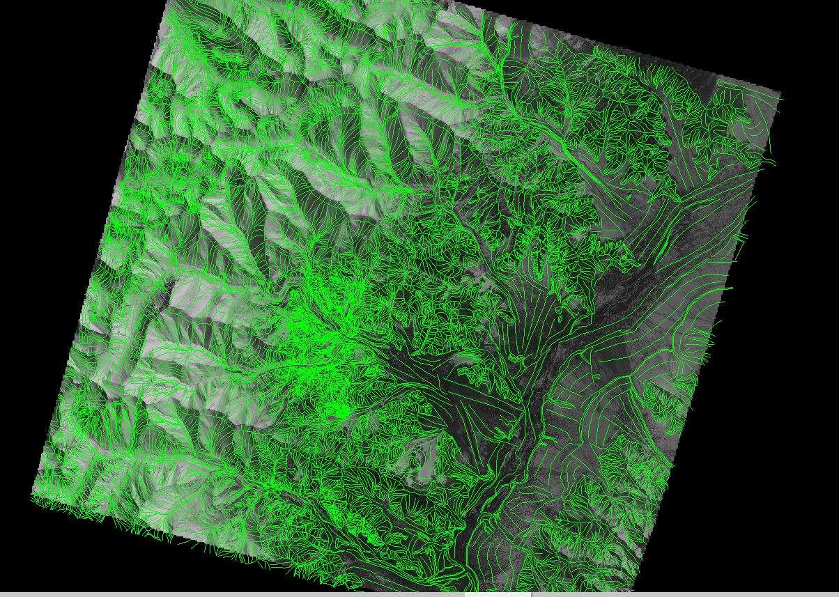
DTM\DEM Extraction
Digital Terrain Modeling (DTM) is the collection of mass points of elevations and 3D break lines at each change of terrain using softcopy workstations.
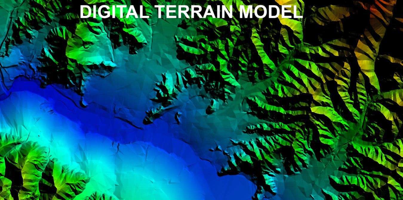
We generate high-quality DTM/DEM for topographical mapping as well as for DTM for Orthophoto generation too.
Atom provides high-quality Digital Elevation Models. We place great emphasis on accurate terrain representation by collecting additional spot elevations and break lines thereby ensuring the highest quality deliverables.
We provide the following services for elevation models
- High-quality DTM/DEM/DSM/DHM
- Elevation data in different formats – ESRI Grid, Erdas Img, any other rater or vector format
- Topographic Contours
- Elevation data quality statistics
- Slope analysis
- Flood and Volumetric analysis
For more information please contact us
Digital Ortho Photography & Photogrammetry
Digital Orthophoto is a raster image generated by differentially rectifying aerial photographs or satellite images to compensate for distortions due to the altitude of the aircraft and the relief of the terrain. It also combines the image characteristics of a photograph with the geometric qualities of a map.
Atom has carried out several large ortho rectification projects worldwide, with the best skill resources and high-end Software like OrthoBox from INPHO
We have expertise in the following types of ortho-rectification Photogrammetry.
- Conventional Ortho
- True Ortho
- CIR Ortho
- RGB Ortho
- Satellite image rectification
We are capable of handling large numbers of images in one go i.e. 2000 to 5000 images from low resolution to high resolution
For more information please contact us
Atom has experience with more than 100 projects of mine mapping starting from the feasibility study process to the closing and monitoring process of the mine.
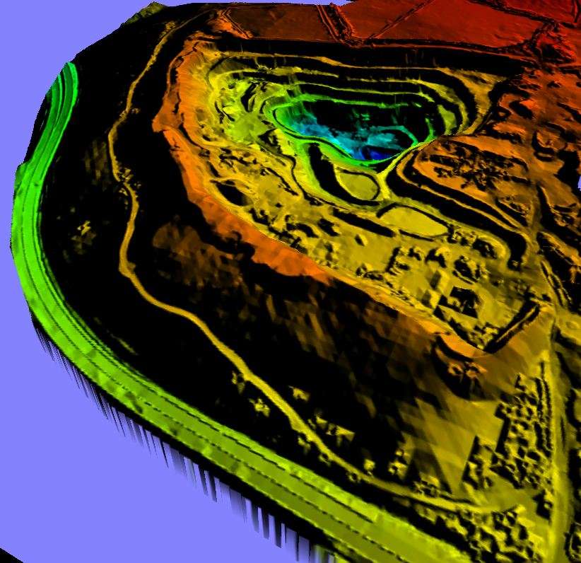
Atom is expertise in all specifications of open cast mines like Stock Piles, Benches, Blast areas, Pit and Spoil areas, waste dumps, Tailing dumps, Camp areas, etc.
We work for various mining sectors like Iron ore, Coal, Gold, etc. for the clients of different continents of the world like India, Australia, South Africa, Canada, USA, etc
We also create high-quality DTM/Mapping and Orthos Photogrammetry using high-resolution satellite images which is an extremely cost-effective method of doing feasibility studies for the mines.
For more information please contact us
Space (Satellite) Photogrammetry
As space technology is moving fast in delivering the high resolution of satellite images, we are also moving forward to use the same for various applications.
Atom is expertise in using high-resolution stereo satellite imagery by our latest and high-end software for creating various products for different industry sectors.
We are capable of handling Cartosat-1 (2.5M), IKONOS (1.0M), Geoeye-1(0.5M), Worldview-1 and 2, etc.
We can create high-quality DTM/Mapping and Orthos using high-resolution satellite images which is an extremely cost-effective method for creating these kinds of products.
For more information please contact us
Atom has carried out various projects for terrestrial surveys using metric and amateur cameras. Atom provides the following services for close-range and terrestrial survey Photogrammetry
- Terrestrial photography acquisition
- 3D restitution of buildings and Monuments
- Architectural mapping and analysis
- Plant and Engineering Mapping
- Facade mapping
- 3D Projection Mapping
For more information please contact us.
